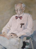
Beeldcollectie Dr. Johan Hartog, St. Martin/Sint Maarten, no. 001-06-061
"Foto's gebruikt voor boek Dr. Hartog - St. Maarten"
<< Previous image || Next image >>
Notes:
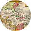
Foto, 180 x 240 mm, zwart/wit
Hulst van Keulen{Archief Kon. Marine, 's Gravenhage, inv. No' 3425).
Achterzijde Nota blad: 47. Kaart van Sint Maarten, vermoedelijk 1791, van Ger. Hulst van Keulen (Archief Kon. Marine, 's-Gravenhage, inv. No. 3425). Op het Nederlandse gedeelte worden hier Nederlandse namen gebruikt, zoals Groote Blinde Straat (Cul-de-Sac), De groote zoutkeet (voor de grote zoutpan), Oesterkreek (Oysterpond), Het Witte Punt (Pointe Blanche); merkwaardig zijn de benamingen Steenbaai voor de Laybay en Prinsessenkwartier voor Princes' Quarter. Van historisch belang zijn de Grenslijnen van betwiste gebieden: de stippellijn geeft aan de Ancienne ligne de s‚parations du gouverneur hollanois 1764: met bij het Quartier d'Orl‚ans nog een derde lijn(stippellijn), welke een Kwestie van 1756 betreft. Sterk afwijkend van de tegenwoordige situatie is de doorbraak van Simpsonsbaai-lagoen naar de Anse de Sables.
For inquiries and requests regarding use of (high-resolution) images for publications, audiovisual productions etc., please contact [email protected].
photos Beeldcollectie Dr. Johan Hartog St. Martin Sint Maarten Saint Martin SXM Landkaart Eiland Sint Maarten
Part of these collections:


Copyright not evaluated
Metadata: XML, JSON
Full item record: Internet Archive