Coleccion Aruba > Browse > The West Indian Atlas or a general description of the west Indies : Taken from actual surveys and observations (1775) (Jefferys, Thomas)
Creator: Jefferys, Thomas
Date: 1775
Language: English
Description:
The West Indian Atlas or a general description of the west Indies : Taken from actual surveys and observations / by Thomas Jefferys, Geographer to the King
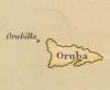
Aruba: p. 10
Persistent link: https://bibliotecavirtual.defensa.gob.es/BVMDefensa/es/consulta/registro.do?id=83914
Notes:
Plate A. A Chart of the British Channel -- Plate B. The Atlantic Western Ocean -- Plate C. The Açores or Wesern Islands -- Plate D. The Madeiras, and of Canary Islands -- Plate E. The Cape de Verd Islands -- Plate F. The Bermudas or Summer's Islands -- Plate 1. The General Index - Map of the West - Indies. -- Plate 2. The Western Coast of Lousiana, and the Coast of New Leon -- Plate 3. The Coast of West Florida and Louisiana -- Plate 4. The Peninsula and Gulf of Florida, and the Bahamas Islands -- Plate 5. The Coast of Yucatan, from Laguna de Esmotes to Punta Brava -- Plate 6. The coast of Yucatan, from Campeche to Bahia del Ascension, with the West End of Cuba -- Plate 7. The Island of Cuba, with part of the Bahama Banks and The Martyrss -- Plate 8. The Windward Passage, with the several passages from the west End of Cuba, and the North Part of St. Domingo -- Plate 9. The Coast of New Spain from Neuva Vera Cruz to Trieste Island -- Plate 10. The Bay of Honduras -- Plate 11. The Island of Jamaica, and Cape Gracias a Dios, with the Banks -- Plate 12. The South Part of Domingo -- Plate 13. The Caribee Islands, the Virgin Islands, and Porto Rico -- Plate 14. Part of the Provinces of Costa Rica and Nicaragua, with the Lagunas -- Plate 15. The Isthmus of Panama, with the coasts from the great River on the Moskito Shore to Carthagena -- Plate 16. The Coast of Terra Firma, from Carthagena to Golfo Trieste -- Plate 17. The Coast of Caracas, Cumana, Paria, and the Mouths of Rio Orinoco, with the Islands of Trinidad, Margarita, Tobago, Granada, St. Vincent & c. -- Plate I. The Island of Jamaica -- Plate II. The Island of Ruattan, or Roattan, with the Island or Old Provindence -- Plate III. The Virgin Islands, with the Islands of Anguilla, Saba, St. Eustatia, St. Martin's, the Great Passage Island, and Crab Island, with a Part of Porto Rico -- Plate IV. The Island of St. Chistopher, and the Island of Nevis -- Plate V. The Island of Antigua -- Plate VI. The Island of Guadaloupe, with the Island of Mariegallante -- Plate VII. The Island of Dominica -- Plate VIII. The Island of Martinica -- IX. The Island of St. Lucia -- Plate X. The Island of Barbadoes -- Plate XI. The Island of St. Vicent -- Plate XII. The Island of Beguia, or Becochya -- Plate XIII. The Island of Granada -- Plate XIV. The Island of Tobago -- Plate XV. Turks Islands -- Plate XVI. The Island of Curaçao
Part of these collections:


License/rights/reuse information:
Copyright not evaluated
View this item in its original context:
https://bibliotecavirtual.defensa.gob.es/BVMDefensa/es/consulta/registro.do?id=83914
Full Text/Transcription: XML - TXT
Metadata: XML - JSON
IIIF: View Manifest - Open in Mirador Viewer
Full item record: Internet Archive
Copyright not evaluated
View this item in its original context:
https://bibliotecavirtual.defensa.gob.es/BVMDefensa/es/consulta/registro.do?id=83914
Full Text/Transcription: XML - TXT
Metadata: XML - JSON
IIIF: View Manifest - Open in Mirador Viewer
Full item record: Internet Archive
coleccion.aw - Un solo portal pa e herencia documental y audiovisual di Aruba.Mas informacion/contribui/bira partner: Tuma contacto cu nos!